Good start to the day - no rain & clouds lifting. Laura wasn't riding and is almost over the ?whatever? she had. Unfortunately there are those who are still suffering.
I was riding along quickly. My plan was to "give 'er" for the first 70 km to the lunch stop, and then take it easy with lots of photos afterwards. I stopped for a few photos. This is a shot from the road, looking east towards the Amazon. Interesting tree on the left.
About 40 km I stopped to help a fellow (Belgian 'Chris') who hit a pothole and 'cranged' (technical term) his rim. We straightened it out a bit, but he ended up getting picked up by the bus.
About this time we (rider 'Asha' & I) were passed by 3 busloads & two lorries of army guys.
This is an interesting photo. We saw lots of wood piled up alongside the road very neatly. My guess is that is going to some small private sawmills (an Alaskan mill or smaller). We've passed a number of these in the last few days. Some look like they are making wooden boxes (kind of like Japanese orange crates of old). The wood is definitely poor quality.
 At about 0930 a.m. and 70 km I cross the Rio Pastaza. Nice looking, modern cable stayed bridge.
Oh, oh! All the army guys and a whole bunch of police are here, along with our lunch truck and Christiano in the pickup. It turns out that the Indiginous Ecuadorians are protesting and had blocked the road at km 98. Christiano talked to the protesters and was dissuaded with the spears, guns, and blow darts. We hang around here (there is a restaurant) for quite a while amusing ourselves by taking photos of:
The police & army guys (note the tear gas canisters)

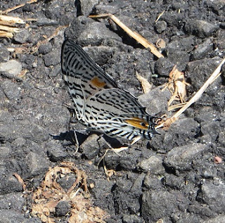
Trying to take photos of butterflies. It seemed too hot for them, so they kept their wings folded. This one had beautiful blue patches on top of the wings, but it wouldn't hold still
People pictures
After an hour or so, we had a rider's meeting where Christiano told us the road was still blocked. They had found a 'resort' about 1/2 km away that could take us. So, off we bike / trudge to this place, at the junction of the Rio Pastaza & Rio Chiguaza rivers.
The coordinates are South 1 deg 54.868 min., West 77deg 49.574 min.
Photos of the place:
Note how everybody has jammed their tent under cover. We were too slow (polite?) and are outside.
What do you think, Julie?
Rustic enough?
The original suspension bridge over the Rio Pastaza is in the background
2510 The new bridge over the Rio Chiguaza. Good for one car only (2 x 10 decking!)

The junction of the two rivers with the new bridge in the background. Note the difference in colours of the two rivers.
We also have lots of fauna photos which we'll post some time.
So, today turned out to be very interesting. We'll find out what is going on and keep you posted. No Internet today so we'll post it later.
(August 19 - we are near Tantzaza and I am trying to catch up. After tomorrow is a rest day, so maybe.....)


No comments:
Post a Comment